Drones for 2D Mapping and 3D Models
Ireland’s Premier Aerial Construction Drone Photography & Videography Services
Top Drone delivers the best all-round aerial drone services for construction nationwide – from Dublin to Donegal. Specialising in ultra-sharp 4K drone photography, cinematic construction videography, and precision aerial surveying, we help engineers, architects, developers, and local authorities visualise projects with unmatched clarity and efficiency.
Super-Sharp Aerial Imagery with Advanced 2D Drone Mapping & 3D Modelling
Our IAA & CAA certified drone pilots use cutting edge RTK GPS-enabled drones to capture accurate aerial data, producing:
Ready for Next-Level Construction Insights?
Whether you're managing a wind farm in Galway, a housing development in Cork, or infrastructure upgrades in Dublin, our drone construction surveying services deliver actionable data that drives decisions.
Get Your Free Site Assessment & Quote Today – includes:
• Sample orthomosaic preview
• Data export in your preferred format (GeoTIFF, LAS, OBJ, etc.)
• Full GDPR & aviation compliance
ORTHOMOSAIC MAPPING
Drone Mapping
Our 2D drone mapping service uses high-resolution orthophotos captured from the air to create accurate, detailed maps of your site. The drone photographs the area using hundreds of overlapping images, which are then processed through advanced cloud-based mapping software. These images are stitched into a single, high-accuracy orthomosaic map ideal for construction, planning, inspections, and documentation.
We can also generate digital elevation models (DEMs) that highlight ground highs and lows, giving you a clear understanding of site levels, volumes, and topography.
2D drone mapping offers major benefits over traditional surveying — it’s faster, safer, and significantly more cost-effective. Instead of sending engineers or surveyors across large or hazardous sites, a single drone flight provides a full, up-to-date visual record. It reduces time on site, cuts operational costs, and greatly improves workforce safety by eliminating the need for staff to climb tall structures or access awkward, risky areas.
Drone Mapping of Maghery Pier
You can take measurements of various parts of the 2D aerial map, zoom in and out, add markers, measure stockpiles, and view an elevation map. All done using the various tools.
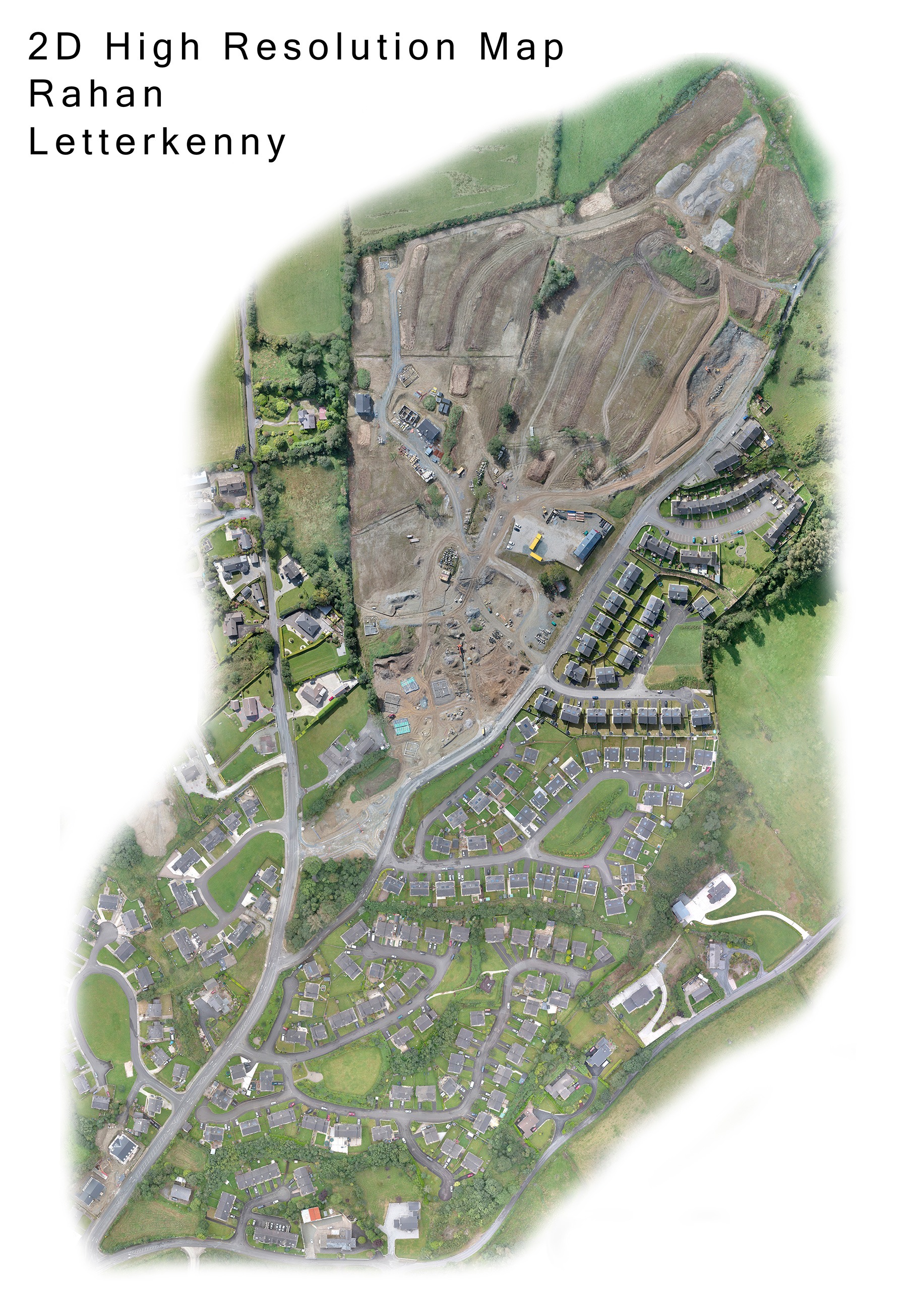
2D Aerial Map We Completed for Donegal County Council
This detailed 2D drone map was generated from more than 1,000 high-resolution orthophoto images, captured in a precise grid pattern and stitched together using professional mapping software.
The final file size reached 345MB, and at full print resolution, the map would measure around 10ft by 7ft. This section represents only a small part of a much larger aerial survey covering most of Letterkenny.
Projects like this highlight the scale and accuracy achievable with our drone mapping services in Ireland.
We can cover large areas quickly, safely, and at a fraction of the cost of traditional ground surveys. Whether you need orthophoto maps, 2D construction site surveys, land assessments, or high-accuracy aerial data, our drone mapping workflow delivers reliable results that support planning, monitoring, and decision-making across all sectors.
3D MODEL
Drone 3D Modeling
Using advanced drone technology and specialised photogrammetry software, we capture highly accurate 3D models of buildings, structures, and construction sites.
These detailed digital twins offer a precise, measurable view of your project from every angle.
With these professional 3D drone models, you gain powerful insights that help reduce costs, cut waste, and streamline workflows.
From planning and monitoring to reporting and decision-making, 3D modelling gives your team clearer information, faster turnaround, and a safer way to assess complex or hard-to-reach areas.
• 3D Construction Models
• 3D Models of Building Sites
• 3D Models of Statues or Monuments
Why Use Top Drone?
Licensed
We are IAA certified and adhere to all current IAA (Irish Aviation Authority) guidelines.
Insured
We operate with full Public Liability Insurance. If you hire an uninsured drone pilot you could be held liable for any accidents or damage caused.
Competitive Pricing
We will match any genuine quote...